


Continents BY SIZE
BY POPULATION 2005 est.
NUMBERS OF COUNTRIES
Note: In some parts of the world students are taught that there are only six continents, as they combine North America and South America into one continent called Americas. Other experts use only six continents by combining Europe and Asia into a continent called Eurasia.
Americas(42,075,000 sq km) (825,000,000)
Eurasia(54,697,000 sq km) (4,406,000,000)
Convert km (kilometers) to miles,…..multiply kilometers by: 0.621371
Convert sq km (kilometers) to sq miles,…..multiply kilometers by: 0.386102
- 1 Asia – (44,579,000 sq km)
- 2 Africa – (30,065,000 sq km)
- 3 North America – (24,256,000 sq km)
- 4 South America – (17,819,000 sq km)
- 5 Antarctica – (13,209,000 sq km)
- 6 Europe – (9,938,000 sq km)
- 7 Australia/Oceania – (7,687,000 sq km)
BY POPULATION 2005 est.
- 1 Asia – (3,879,000,000)
- 2 Africa – (877,500,000)
- 3 Europe – (727,000,000)
- 4 North America – (501,500,000)
- 5 South America – (379,500,000)
- 6 Australia/Oceania – (32,000,000)
- 7 Antarctica – (0)
NUMBERS OF COUNTRIES
- 1 Africa – (53)
- 2 Europe – (46)
- 3 Asia – (44)
- 4 North America – (23)
- 5 Oceania – (14)
- 6 South America – (12)
- 7 Antarctica – (0)
Note: In some parts of the world students are taught that there are only six continents, as they combine North America and South America into one continent called Americas. Other experts use only six continents by combining Europe and Asia into a continent called Eurasia.
Americas(42,075,000 sq km) (825,000,000)
Eurasia(54,697,000 sq km) (4,406,000,000)
Convert km (kilometers) to miles,…..multiply kilometers by: 0.621371
Convert sq km (kilometers) to sq miles,…..multiply kilometers by: 0.386102
| Continent | Area (km²) | Approx. population 2002 |
Percent of total population |
Density People persquare kilometre |
|---|---|---|---|---|
|
|
||||
| Asia | 43,810,000 | 3,800,000,000 | 60% | 86.7 |
| Africa | 30,370,000 | 922,011,000 | 14% | 29.3 |
| Americas | 42,330,000 | 890,000,000 | 14% | 20.9 |
| North America | 24,490,000 | 515,000,000 | 8% | 21.0 |
| South America | 17,840,000 | 371,000,000 | 6% | 20.8 |
| Antarctica | 13,720,000 | 1,000 | 0.00002% | 0.00007 |
| Europe | 10,180,000 | 710,000,000 | 11% | 69.7 |
| Oceania | 9,010,000 | 33,552,994 | 0.6% | 3.7 |
| Australia-New Guinea | 8,500,000 | 30,000,000 | 0.5% | 3.5 |
| Australia mainland | 7,600,000 | 21,000,000 | 0.3% | 2.8 |
Definitions and application“Continents are understood to be large, continuous, discrete masses of land, ideally separated by expanses of water.” However, many of the seven most commonly recognized continents are identified by convention rather than adherence to the ideal criterion that each be a discrete landmass, separated by water from others. Likewise, the criterion that each be a continuous landmass is often disregarded by the inclusion of the continental shelf and oceanic islands. The Earth’s major landmasses are washed upon by a single, continuous World Ocean, which is divided into a number of principal oceanic components by the continents and various geographic criteria.Extent of continents The narrowest meaning of continent is that of a continuous area of land or mainland, with the coastline and any land boundaries forming the edge of the continent. In this sense the term continental Europe is used to refer to mainland Europe, excluding islands such as Great Britain, Ireland, and Iceland, and the term continent of Australia may refer to the mainland of Australia, excluding Tasmania. Similarly, the continental United States refers to the 48 contiguous United States in central North America and may include Alaska in the northwest of the continent (both separated by Canada), while excluding Hawaii in the middle of the Pacific Ocean.
From the perspective of geology or physical geography, continent may be extended beyond the confines of continuous dry land to include the shallow, submerged adjacent area (the continental shelf) and the islands on the shelf (continental islands), as they are structurally part of the continent. From this perspective the edge of the continental shelf is the true edge of the continent, as shorelines vary with changes in sea level. In this sense the islands of Great Britain and Ireland are part of Europe, and Australia and the island of New Guinea together form a continent (Australia-New Guinea).
As a cultural construct, the concept of a continent may go beyond the continental shelf to include oceanic islands and continental fragments. In this way, Iceland is considered part of Europe and Madagascar part of Africa. Extrapolating the concept to its extreme, some geographers take Australia, New Zealand and all the islands of Oceania (or sometimes Australasia) to be equivalent to a continent, allowing the entire land surface of the Earth to be divided into continents or quasi-continents.
Separation of continents
The ideal criterion that each continent be a discrete landmass is commonly disregarded in favor of more arbitrary, historical conventions. Of the seven most commonly recognized continents, only Antarctica and Australia are separated from other continents.
Several continents are defined not as absolutely distinct bodies but as “more or less discrete masses of land”.[11] Asia and Africa are joined by the Isthmus of Suez, and North and South America by the Isthmus of Panama. Both these isthmuses are very narrow in comparison with the bulk of the landmasses they join, and both are transected by artificial canals (the Suez Canal and Panama Canal, respectively) which effectively separate these landmasses.
The division of the landmass of Eurasia into the continents of Asia and Europe is an anomaly, as no sea separates them. An alternative view, that Eurasia is a single continent, results in a six-continent view of the world. This view is held by some geographers and is preferred in Russia, East European countries and Japan (which spans Asia and Europe). The separation of Eurasia into Europe and Asia is viewed by some as a residue of Eurocentricism: “In physical, cultural and historical diversity, China and India are comparable to the entire European landmass, not to a single European country. A better (if still imperfect) analogy would compare France, not to India as a whole, but to a single Indian state, such as Uttar Pradesh.” However, due to historical and cultural reasons, the view of Europe as a separate continent continues in several categorizations.
North America and South America are now treated as separate continents in much of Western Europe, India, China, and most native English-speaking countries, such as the United States, Canada, Australia, and New Zealand[citation needed]. Furthermore, the concept of two American continents is prevalent in much of Asia. However, in earlier times they were viewed as a single continent known as America. From the 19th century some people used the term “Americas” to avoid ambiguity with the United States of America. The plurality of this last term suggests that even in the 19th century some considered the New World (the Americas) as two separate continents. North and South America are viewed as a single continent, one of six in total, in some parts of Europe, and much of Latin America[citation needed].
When continents are defined as discrete landmasses, embracing all the contiguous land of a body, then Asia, Europe and Africa form a single continent known by various names such as Afro-Eurasia. This produces a four-continent model consisting of Afro-Eurasia, the Americas, Antarctica and Australia.
When sea levels were lower during the Pleistocene ice age, greater areas of continental shelf were exposed as dry land, forming land bridges. At this time Australia-New Guinea was a single, continuous continent. Likewise North America and Asia were joined by the Bering land bridge. Other islands such as Great Britain were joined to the mainlands of their continents. At that time there were just three discrete continents: Afro-Eurasia-America, Antarctica, and Australia-New Guinea.
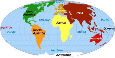
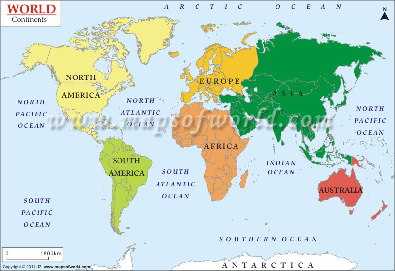
The world continent map shows the distribution of the continental landmasses on the surface of the Earth. In terms of area, the continental landmasses are concentrated more in the Northern Hemisphere than in the Southern Hemisphere, as per the statistics of world continents and oceans. In maps , Asia is by far the largest continent and being adjacent to Europe, the two are sometimes referred to as a single continent, termed as Eurasia; although there are marked differences between the two continents on varied fields ranging from physical features to culture and socio-economic realities. Africa, Australia, Antarctica, and North and South America form the rest of the continental landforms.While each continent displays its unique physical and cultural characteristics, according to the continental drift theory, the continental plates are constantly shifting relative to each other. It is believed that about 200 million years ago, all of the continents were part of a singular landmass known as Pangaea which broke away due to continental drift and the plates gradually moved away from each other resulting in the emergence of the seven continents as we know them today. This drifting apart had also resulted in the expansion of the sea floor and the opening up of the ocean basins. It also led to the emergence of certain mountain ranges when two landmasses collided and pushed against each other. Proponents of this theory have supported their hypotheses by geological evidences such as identical or similar fossil findings and ancient rocks, and the prevalence of similar flora and fauna in two continents located far away from each other. Looking at the world continents and oceans map, it cannot be denied, however, that each of the world continents is unique in terms of its peculiar physical and cultural diversity which deserves our attention.
Asia: Asia Asia is bounded to the north by the Arctic Ocean, to the East by the Pacific Ocean, to the south by the Indian Ocean, and to the West by Europe and the Mediterranean. A continent of contrasts and extremes, the enormous diversity of Asia’s physical and cultural landscape is unparalleled in the world. Although geographers have clubbed its constituent nations and regions as part of one large continent, Asia defies all notions of homogeneity. Asia includes some of the world’s richest and developed economies like Japan and Korea but is also home to some of the world’s poorest nations. Asia has the highest point on Earth, the Mount Everest in the Himalayas, as well as the lowest place on land, the Dead Sea. Asia also experiences the wildest extremes of weather and climate. While the continent boasts of the wettest place on Earth in the Indian state of Meghalaya, certain areas in the Arabian Desert may go without rainfall for years together. Asia also has the widest variety of plant and animal life; from tropical rainforests to desert scrubland; from the world’s largest reptile, the Komodo Dragon of Indonesia, to the shy and elusive Snow Leopard in the high reaches of the Himalayas.
Europe: One of the world’s smallest continents, Europe is bounded to the north by the Arctic Ocean, to the west by the Atlantic Ocean, to the south by the Mediterranean Sea, the Black Sea, and the Caspian Sea, and to the east by the Ural Mountains which separate the continent from Asia and the greater part of the vast Eurasian landmass. Despite its internal diversities of culture, language, customs, etc., Europe has come to represent a unique civilization and ethical values which had a tremendous influence on the rest of the world at different epochs of history. Europe is a continent of great physical and cultural diversity and is bestowed with some of the world’s most spectacular landscapes and places of scenic beauty. From the tiny hilltop villages of France to the bustling metropolises of London and Paris; from the skislopes of the Austrian Alps to the sun-kissed beaches of Mediterranean Spain; from the fairy-tale castles of the Scottish Highlands to the Gondolas of Venetian canals; the breathtaking beauty of Europe is a feast for the eyes.
Australia: The world’s smallest continent, Australia is also regarded by many as the youngest, since civilization started much later here but the history and culture of its original inhabitants, the Aborigines, goes back to more than 50,000 years. With the Pacific and Indian Oceans on either side, Australia’s location in the Southern Hemisphere and relative isolation has rendered it with a unique variety of plant and animal life found nowhere else on Earth. Although, a major portion of the continent’s land area is covered by arid desert topography, Australia’s natural sights are a big draw for the outside world. From the tropical rainforests and the Great Barrier Reef in the north to the vibrant coastal cities of Sydney and Melbourne in the south east; from the endless straight roads of the arid outback to the spectacular coastal scenery of the Great Ocean Road; from the lonely Ayers rock in the middle of nowhere to the crowded beaches of Bondi and Manly; Australia is a dream come true for many travelers and adventure-loving people.
Africa: The second largest of the world’s continents, Africa is bounded to the north by the Mediterranean Sea, to the west by the Atlantic Ocean, to the east by the Indian Ocean and the Red Sea, and to the south by the juncture between the Atlantic and the Indian oceans. Variously described by outsiders, as the ‘Dark Continent’ or ‘the Cradle of Mankind’, Africa is a continent immensely rich in mineral and natural resources that helped attract plunderers and explorers alike. Africa is also blessed with a rich variety of wildlife and biological resources, the preservation of which continues to be a challenge for conservationists from across the world. Africa is also home to some of the world’s poorest people and many of its constituent countries are still undergoing the process of nation building to achieve integration with the rest of the world.
North America: The third largest of the world’s continents, most areas of the North American landmass is occupied by two of the world’s most developed nations, the United States of America and Canada. The third major country occupying this continent is Mexico. The continent of North America is bounded to the north by the Arctic Ocean, to the east by the Atlantic Ocean, to the west by the Pacific Ocean, and on the south by the Caribbean Sea. It is connected to the continent of South America by the narrow Isthmus of Panama. Comprising of some of the world’s oldest rocks North America is also very rich in mineral and other natural resources. National Parks in this continent contain some of the most spectacular and breath-taking sceneries in the world.
South America: Culturally sometimes referred to as Latin America, the continent of South America has the greatest north-south extension and apart from Antarctica, is the only continent with the farthest extension to the south. South America is bounded to the north by the Caribbean Sea, to the East by the Atlantic Ocean, to the west by the Pacific Ocean, and to the south by the icy continent of Antarctica. South America’s high mountains and highland areas extend up to different elevation levels which together contribute to its variety of climate and natural regions ranging from the high Andes Mountains to the Amazon rainforests; and the arid Patagonian and Atacama deserts to the sub-arctic climes of its southernmost areas.
Antarctica: In any world map , the southernmost and the most remote continent, Antarctica is permanently covered under ice. The difficulties of accessibility have, however, not discouraged several scientific expeditions and initiatives which are being currently undertaken by several nations to this part of the world. Many developed nations and even developing countries like India have set up scientific stations in Antarctica and many of them have made their own territorial claims on this vast icy continent.